James Family Archives
• Researching the Past
• Education for the Present
• Preservation for the Future
Retracing the Gozzaldi Expedition to Wales in 1890
by Larry P. James
April 18, 2012
In the year 1890 Mary Isabella James de Gozzaldi (1852-
Mary Isabella James was born on September 19, 1852 in Burlington, New Jersey. She
was the first child of Thomas Potts James (1803-
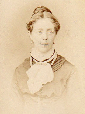
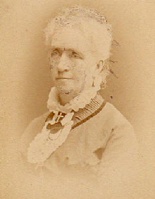
Image No. 1
Mary Isabella James de Gozzaldi (1852-
Image No. 2
Isabella Batchelder James (1810-
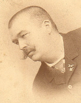
Image No. 3
Silvio Mario Alfredo de Gozzaldi (1854-
Mary was educated at the Berkeley Street School and later traveled abroad to study
painting and languages, including Italian and German. Prior to 1885, while in Europe,
Mary met and became engaged to Silvio Mario Alfredo de Gozzaldi (1854 -
Mary had a lifelong interest in genealogy that she inherited from her mother Isabella.
She was profoundly interested in early American history and was a co-
Marry conducted historic and genealogical research on behalf of many members of the Cambridge Historical Society including the James family. She was also a very active member in the Hannah Winthrop Chapter of the Daughters of the American Revolution. Through her membership in these societies she wrote several articles on early settlers of Cambridge, contributed to the Guide to Cambridge, written by the Daughters of the American Revolution (“D.A.R.”), and wrote an index to Paige’s History of Cambridge. Mary’s husband Silvio died of a stroke in Cambridge on or about 1924. Mary died in her Cambridge home on Sunday, April 6th, 1935 after a sudden and very brief illness.
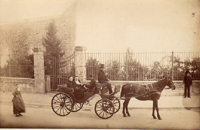
Image No. 4
Inscription Reads, “Mary Gozzaldi, Isabella James and Silvio Gozzaldi in carriage, 1886.”
The Gozzaldi Expedition to Radnorshire represented the culmination of many years
of James family history research carried on by both Mary and her mother Isabella.
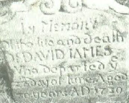
Mary was the direct lineal descendant and great, great, great granddaughter of David
James (c.1660-
The only surviving record from the 1890 Gozzaldi Expedition is a collection of eleven
photographs. These photographs taken during the expedition are among the rarest pictures
ever taken of pre-
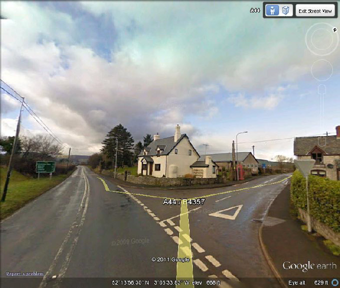
The expedition into Radnorshire began at the small village of Walton, about one mile into Wales from neighboring Herefordshire, England. (Image No. 5) Here Mary and the expedition stopped to photograph a “Y” shaped intersection in the road. The lane veering to the left would lead the Gozzaldi family west to New Radnor about 3½ miles away. Today, this intersection is identified as the convergence of Route A44 west bound and Route B4357 North bound toward the village of Evenjobb. (Image No. 6) The house in the center of the intersection splitting the two directions is the only structure in the photo that survives to the present day.
Image No. 5
The village of Walton, Radnorshire, Wales 1890. Inscription on the photo reads, “3½ miles from New Radnor, Walton, Entrance into Wales from England.”
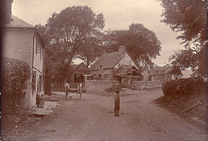
Image No. 6
Current view (2009) of Image No. 5: Walton, Powys, Wales, UK at the intersection of Route A44 headed west toward New Radnor and B4357 headed north to Evenjobb.
The village of Walton also marked the entrance to Radnor Valley, or Walton Basin,
as it is also known. Like old Radnorshire, the valley is now in the county of Powys
in mid Wales, about 5 miles south west of Presteigne, and about the same distance
from Knigton in western Herefordshire. It lies approximately 600 to 800 feet above
sea level. The largest village is New Radnor, and other settlements in the valley
include Llanfihangel-
The Gozzaldi expedition’s first stop of historical interest for the James family
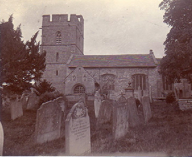
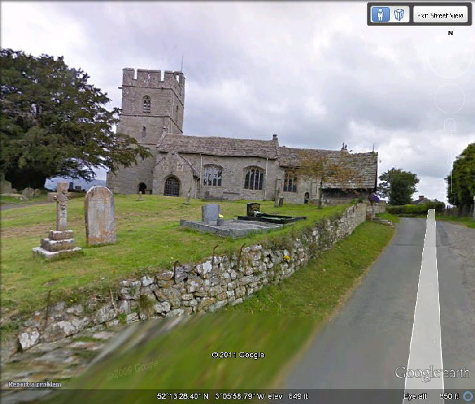
was at Old Radnor, a small village at the top of a hill just outside of Walton where
is located the Harp Inn, a pub, a 15th century longhouse and the ancient church of
St Stephen. (Image No. 7) Considered one of the finest medieval churches in Wales,
St. Stephen’s church hosts considerable architectural interest, a significant range
of internal fittings, and strong evidence of a former curvilinear churchyard. The
tower is 15th century with limited restoration work; the north aisle and north chapel
are 15th century. The east wall was rebuilt in the 16th century during Victorian
times, and the same is true of the chancel. The church building is the oldest surviving
church in the Walton Basin and would have been a well-
Image No. 7
Old Radnor, Radnorshire, Wales 1890. Inscription on the photo reads, “Old Radnor Church.”
The church was originally dedicated to St. Ystyffan prior to the Norman invasion,
and it holds the oldest, 8th century font in Britain; thought to have been a collegiate
church it is now just a simple parish church with a roof that needs replacing. It
stands 840 feet above sea level high on the western side of Gore Hill, currently
being quarried on the eastern side by Tarmac. Ystyffan himself belongs to the late
6th century when he was a member of the royal family that ruled Powys circa 600-
Image No. 8
Current view (2009) of Image No. 7: Old Radnor Church, Old Radnor, Powys, Wales, LD8, UK southwest of Walton off of Route A44.
After paying their respects to the Old Radnor Church, the Gozzaldi expedition cut west through Radnorshire to the village of New Radnor or “Maesyfed” as it is known in the Welsh language. Amidst the very quaint rural surroundings of this medieval township, the James family sought out both a connection to the family’s past and a grim reminder of the dark history of religious persecution that drove the family away from Wales. New Radnor was the original county seat for Radnorshire during the age of intolerance and the family’s flight to the New World. It lies adjacent to Radnor Forest and was originally built to replace Old Radnor. It was once a medieval walled town with streets laid out in a grid pattern. New Radnor was undoubtedly the inspiration for naming the community settled by the James family in Pennsylvania in 1682, “Radnor Township.”
In 1405 King Henry IV of England controlled the castle that stood on the hill overlooking
New Radnor. He garrisoned it with a force of thirty men-
Image No. 9
New Radnor, Radnorshire, Wales 1890. Inscription on the photo reads, “Birds Eye
view of New Radnor -
The Old “Gaol” (Jail) at New Radnor:
In 1874, sixteen years before the Gozzaldi expedition arrived in Wales, Mary Gozzaldi’s
mother Isabella Batchelder James chronicled how David James, an ancestor of Evan
James (1715-
As can be seen in the modern images below, the Old Gaol at New Radnor no longer stands and has been replaced by a structure that serves as an extension of the old Eagle Inn in New Radnor. (Images 11 and 13) By 1820 the county jail serving Radnorshire had been moved to the village of Presteign to the north. Consequently the Old Gaol at New Radnor fell into decay and was no longer functioning by the time the Gozzaldi expedition arrived in 1890. The actual date of its destruction is unknown. Nevertheless, the site remains visually verifiable when compared to the images taken by the Gozzaldi expedition in 1890.
Image No. 10
New Radnor, Radnorshire, Wales 1890. Inscription Reads, “New Radnor Old Gaol [Jail] & Eagle [Hotel], front view, where Quakers were confined.”
Image No. 11
Current view (2009) of Image No. 10: Broad Street, New Radnor, Powys, Wales, UK facing northwest toward site of Old Gaol replaced by modern extension of old Eagle Hotel.
Image No. 12
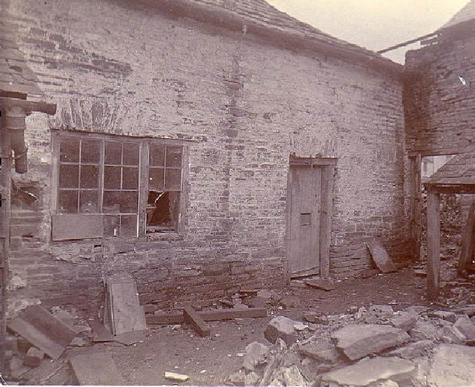
New Radnor, Radnorshire, Wales 1890. Inscription Reads, “Side view of Gaol.”
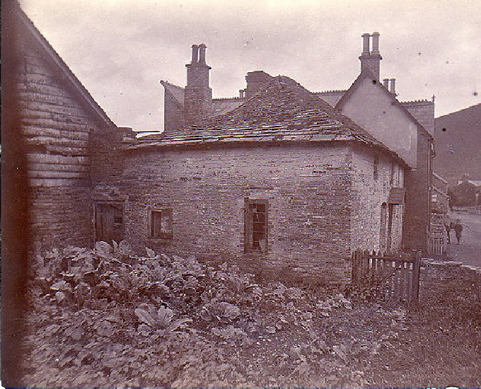
Image No. 13
Current view (2009) of Image No. 12: Broad Street, New Radnor, Powys, Wales, UK facing northwest toward site of Old Gaol.
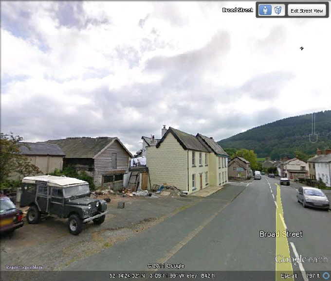
Image No. 14
New Radnor, Radnorshire, Wales 1890. Inscription Reads, “Back of Ancient Gaol at New Radnor.”
Before departing New Radnor, the Gozzaldi expedition captured a few more images including the photo below of the old Kings’ Arms Inn (on the left), a structure that remains today but was more than 300 years old when visited by the Mary Gozzaldi in 1890. (Image 15) It is possible that this is where the members of the Gozzaldi expedition stayed before pressing on deeper into Radnorshire. Undoubtedly, the Kings’ Arms Inn would have been a well known establishment to the James family of the 17th century and may very well have been a resting place for them as they traveled through Radnorshire as well. As one can see from the image that follows, the old Kings’ Arms Inn remains as well as the old drover’s inn across the street. Both of these structures today, however, are used as family residences. (Image 16) The expedition also climbed to the top of New Radnor Castle Mound and took a photo of the view toward the northwest of New Radnor and Whimble Mountain in the distant. (Image 17)
Image No. 15
New Radnor, Radnorshire, Wales 1890. Inscription Reads, “House 300 years old. Entrance onto Radnor Forest & Glascow out of New Radnor.”
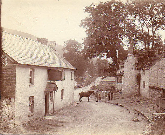
Image No. 16
Current view (2009) of Image No. 15: High Street, New Radnor, Powys, Wales, UK facing west along route headed out of New Radnor.
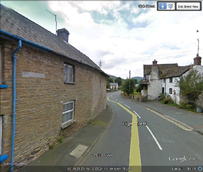
Image No. 17
New Radnor, Radnorshire, Wales 1890. Inscription Reads, “Welsh landscape. Looking from the Castle at New Radnor toward Whimble Mountain 1800 ft. High.”
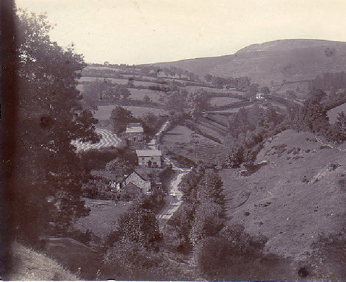
Penybont, Llandegley Parish:
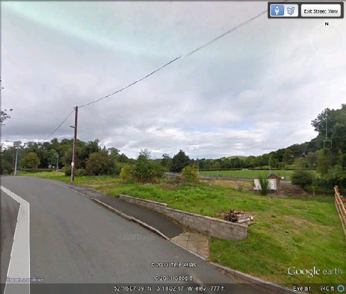
After departing New Radnor, the Gozzaldi Expedition pressed westward deeper into Radnorshire and closer to the James family’s historic roots. Upon arrival in the village of Penybont, the expedition took an extremely rare photo of the Penybont Calvinistic Methodist Chapel. (Image 18) This Church was originally erected in 1822. It was rebuilt in 1835 and finally demolished in 1989. The view in the photo is from a location within 100 yards due south of the Chapel facing north toward the structure and the adjacent swing bridge. The Church and the bridge were once located on the west side of Penybont Village in Llandegley Parish. The precise coordinates of the location from where this photo was taken are: (52°16’04.03” North) by (3°18’02.11” West). By entering these coordinates one can locate the site on Google Earth. (Image 19) The swing bring was eventually replaced with a more modern fixed bridge which is now located along route A44. There is nothing left of the Chapel but an empty field where it once stood. There is, however, a marker inserted into the parapet near the bridge that marks the site. The marker can also be viewed using Google Earth.
Image No. 18
Penybont, Radnorshire, Wales 1890. Inscription Reads, “Penybont Bridge. Swing bridge at end of village.” Also pictured is the River Ithan and the Penybont Calvinistic Methodist Chapel.
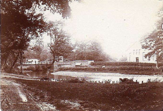
Image No. 19
Current view (2009) of Image No. 18: Penybont, Powys, Wales, UK facing north from the west side of the village. Blue arrow points to modern low profile fixed bridge. Red arrow points to historic marker alongside the road indicating former location of Calvinistic Methodist Chapel that was demolished in 1989.


Penybont Village is located to the west and slightly to the north of Llandegley Village, also in Llandegley Parish, in what is today the County of Powys. The photo in Image 18 was likely commissioned by Mary Gozzaldi as part of her research into the origins of her James family ancestors who were Quakers persecuted in Radnorshire prior to the immigration of her ancestor David James of Llandegley and Glascwm in 1682. The significance of the photo is that it records a very early Methodist Church. The James family was closely affiliated with the Methodists having donated land to the founding of Radnor United Methodist Church in Radnor Township, Chester County Pennsylvania in 1783. The location, Penybont Village, is of equal significance in that the “common” of this village is the site of a very famous gathering where Welsh Quakers from Radnorshire met with George Fox, the founder of the Society of Friends, on or about 1657. In close proximity to this site is also the Pales Meeting House, the original site of Quaker worship in central Radnorshire. The Pales Meeting House lies directly due north of Llandegley and north west of Penybont. It rests on lands that include a cemetery acquired by the Quakers in 1673. The meetinghouse and lands surrounding it, formerly known as “The Soith” are the historic homeland of the James family as referenced in the last will and testament of David ap Rees ap Jevan Athro of Llandegley. Thus the location of this photo is also significant in that Mary Gozzaldi was capturing images of her ancestral homeland as well as images of Quaker and Methodist historical significance.
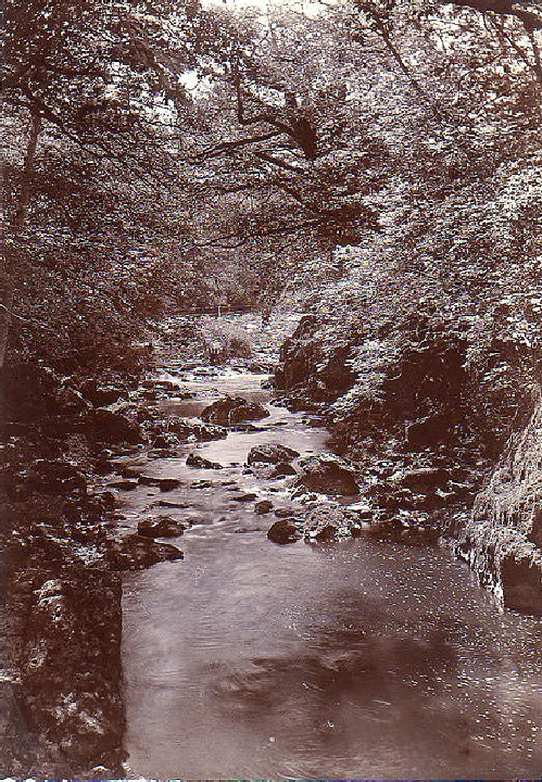
Alpine Rocks in Radnorshire:
After passing through Llandegley Parish and the village of Penypont, the Gozzaldi expedition continued west in the direction of Llandrindod Wells. Along the route Mary had commissioned a photograph, which was entitled “Alpine Rocks in Radnorshire.” (Image 20) Upon closer examination of the photo, it appears that what was actually being photographed was the ruins of a man made mill race, that is, a channel carved out of the rock to redirect the flow of water to a nearby mill that was powered by the flow of the water. Whether or not Mary Gozzaldi and the other members of the expedition were aware that the James family owned and operated a water powered corn and grist mill called “Melin Bussnant” between Llandegley and Glascwm is uncertain. However, the fact that they took interest in what appears to be an ancient millrace certainly suggests they may have possessed that knowledge.
Image No. 20
Llandrindod Wells, Radnorshire, Wales 1890. Inscription Reads, “Alpine rocks near Llandrundod Wells.”
Welshpoole, Montgomeryshire:
After exploring Radnorshire and its environs, the Gozzadi expedition moved west before
completing its journey. The final destination of the expedition appears to be the
town of Welshpoole in neighboring Montgomeryshire just north of Radnorshire. The
town of Welshpoole is the location of many significant events for the James family
prior to its migration to Pennsylvania in 1682. These events would have been well
known to Mary Gozzaldi and the other members of the James family in her company.
For instance, in 1674 Mary’s ancestor, David James, attended a meeting at a house
in Welshpoole called Cloddian Cochion. At that time the town of Welshpoole was regarded
as “within the corporation of Poole.” There a small number of Quakers met together
in silence. Thomas Lloyd (1639-
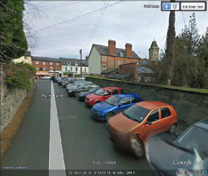
Welshpoole was also host to the notorious “Old Crib”, or gaol, where numerous Quakers had already been imprisoned during the 17th century, some for many years including Thomas Lloyed during the reign of Charles II. (Image 21) The building was situated at the back of Mr. Fred Anderson’s premises on High Street, but was demolished in 1899, just nine years after the Gozzaldi expedition’s visit, and another building was erected on the site. As of 1958 only part of the old structure remained, one corner of the old building at the back. Today, the site is somewhat obscured by a wall that runs the length of Park Lane. (Image 22) Nevertheless, the back of Mr. Fred’s Anderson’s old premises as well as the Welshpoole clock tower is still clearly visible. The only other known image of this ancient structure is a drawing made by Robert Own, showing the building as it was originally, in Volume 38 of Montgomeryshire Collections.
Image No. 21
Welshpool, Radnorshire, Wales 1890. Inscription Reads, “Quaker Prison and Town Hall Tower, Welsh Pool, Wales.”
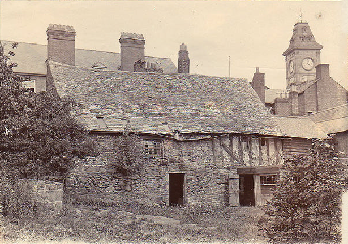
Image No. 22
Current view (2009) of Image No. 21: Welshpool, Powys, Wales, UK view from Park Lane facing northeast with Town Hall Tower at center right. Blue arrow points to former location of old Quaker prison.

The Gaol was a two-
Finally, Welshpoole was also the location of where David James purchased his rights to the 100 acres of land in Radnor Township, Pennsylvania from Richard Davies and his Land Company No. 7 in 1681 before departing Wales in 1682. Hence, the significance of Welshpoole for the James family clearly made that old Montgomeryshire township a priority for the Gozzaldi expedition prior to its departure from Wales. The images captured by Mary Gozzaldi in Wales are among the most priceless artifacts pertaining to James family history in existence. We are eternally grateful for what she recorded and the legacy preserved for future generations of James family members.
Sources
See, Photographs and biographical information obtained from Mary Isabella Gozzaldi
Papers, 1844-
See also, Modern photographs of Radnorshire obtained from Google Earth.
See also, Cloddiau Cochion and the Welsh Quakers by A.R. Lewis Saul, Montgomery collections
relating to Montgomeryshire and its borders, Vol. 55, Part 2 (1958), p. 202-
See also, Collections Historical and Archaeological Relating to Montgomeryshire and its Borders Collections; Volume 38 (1918), p. 158.
See also, Early History of the James Family as Recorded by Isabella Batchelder James
(1810-
See also, Obituary of Isabella Batchelder James (1810-
See also, Information on New Radnor obtained from Clwyd Powys Archaelogical Trust,
Historic Settlements Survey – Radnorshire, New Radnor, SO 212608-
___________________________________________________________________________________________________
Updated: January 5, 2026